|
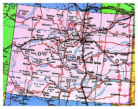
A trip out west sounded good, but where to go? My preference has usually
been to cover territory, cross several state lines, or reach some
obscure destination 1,000 miles or more away. Our starting and ending
point would be Golden, Colorado, but everything else was wide open.
For a change, we decided to confine our trip entirely to Southwest
Colorado, covering almost every interesting paved road we could find on
the map, and relying on local information regarding things to see, and
places to stay and eat, and roads to avoid. We mapped out a route
covering 250-325 twisty miles a day and for once actually made
reservations at campgrounds and the single motel we splurged on during
the trip. It was, after all, the week of July 4, and we didn't want to
be caught without lodging in some remote area late in the day. Locals
warned that even in July the weather could turn cold, especially at the
altitudes at which we would be riding and camping, so we packed long
johns, fleece and electric clothing into our saddlebags and tank bags.
All of it would prove to be unnecessary.
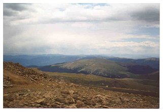 Monday, July 2: For the first day of our trip, we planned a day ride out
of Golden to shake down the bikes at high altitude and to help ourselves
become acclimated as well. We took Route 5 to the top of Mount Evans,
the "highest road in Colorado" at 14,220 feet. We whistled through the
aspens and gaped at the spectacular views, passing what light traffic
there was at (mostly) legal speeds. At the tree line, the aspens gave
way to scrub bushes and then to rocky tundra and the road became a
series of long switchbacks. The weather became cloudy, drizzly and
cooler, with intermittent lightning. The bikes, two fuel injected
Guzzis, an injected Triumph 595 Daytona and an airhead R80 g/s, did well
enough, losing a little power and running a bit punky below 3,500 rpm,
but the human machinery we brought along was also affected. No one fell
ill with altitude sickness, but we all declined to hike the short, steep
trail leading from the end of the road to the summit. A couple of more
daring tourists were not so lucky, and lay on blankets in the parking
lot gasping like fish out of water. No matter what the altitude,
bicyclists of all ages were omnipresent, pumping up the hills with
Sherpa-like lungs.
Monday, July 2: For the first day of our trip, we planned a day ride out
of Golden to shake down the bikes at high altitude and to help ourselves
become acclimated as well. We took Route 5 to the top of Mount Evans,
the "highest road in Colorado" at 14,220 feet. We whistled through the
aspens and gaped at the spectacular views, passing what light traffic
there was at (mostly) legal speeds. At the tree line, the aspens gave
way to scrub bushes and then to rocky tundra and the road became a
series of long switchbacks. The weather became cloudy, drizzly and
cooler, with intermittent lightning. The bikes, two fuel injected
Guzzis, an injected Triumph 595 Daytona and an airhead R80 g/s, did well
enough, losing a little power and running a bit punky below 3,500 rpm,
but the human machinery we brought along was also affected. No one fell
ill with altitude sickness, but we all declined to hike the short, steep
trail leading from the end of the road to the summit. A couple of more
daring tourists were not so lucky, and lay on blankets in the parking
lot gasping like fish out of water. No matter what the altitude,
bicyclists of all ages were omnipresent, pumping up the hills with
Sherpa-like lungs.
 The ride back down Mount Evans was interrupted by several minivans
stopped in the middle of the road by a group of mountain goats. The
goats, looking especially scraggly in the remnants of their winter fur,
didn't seem to care very much that they were blocking traffic, and
leisurely crossed the road and wandered up the near-vertical rock. Due
to better line-of-sight visibility or increased recognition of personal
responsibility, the Colorado Department of Transportation is much more
liberal in their application of the dotted yellow line than our friends
with the Tennessee DOT. After living 70 miles from Deal's Gap, with its
blind curves and dense vegetation, it was disconcerting at first to pass
a slow-moving van on the outside of a curve, and not even be breaking
the law. We got used to it.
The ride back down Mount Evans was interrupted by several minivans
stopped in the middle of the road by a group of mountain goats. The
goats, looking especially scraggly in the remnants of their winter fur,
didn't seem to care very much that they were blocking traffic, and
leisurely crossed the road and wandered up the near-vertical rock. Due
to better line-of-sight visibility or increased recognition of personal
responsibility, the Colorado Department of Transportation is much more
liberal in their application of the dotted yellow line than our friends
with the Tennessee DOT. After living 70 miles from Deal's Gap, with its
blind curves and dense vegetation, it was disconcerting at first to pass
a slow-moving van on the outside of a curve, and not even be breaking
the law. We got used to it.
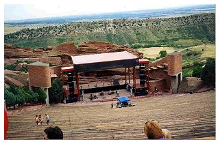
On the way back to Golden, we stopped off at Red Rocks, to check out
the famous natural amphitheater near Morrison. It is indeed spectacular,
formed of vertical walls of red sandstone. A local band was tuning up
for an evening concert, to be followed by a showing of "Independence
Day", and the acoustics are excellent. We headed back to our hosts'
place in Golden, and cleaned up for our sushi night in Denver. We went
to Sonara (SP) in Lower Downtown ("lo-do" to the locals) and had a
fabulous meal, and then walked around lo-do for a while. The weather was
perfect and there were people everywhere, and not a Gap or a Hard Rock
Café to be seen. We loitered in the doorway of Vespa of Denver, looking
at the new scooters from Piaggio.
 Tuesday, July 3: This was the beginning of our trip proper, so we packed
up and hit the road early, taking Highway 40 past Buffalo Lookout to
I-70 for a short blast to Idaho Springs for breakfast. We got back on 40
and headed north, through Berthoud Pass. Traffic was pretty light, but
there was some road construction in places, which slowed us down. Once
we were out of the construction areas, the friendly dotted lines
reappeared, and we made much better time and enjoyed relatively
balk-free travel. Thankfully, the endless lines of Winnebagos we
expected didn't materialize.
Tuesday, July 3: This was the beginning of our trip proper, so we packed
up and hit the road early, taking Highway 40 past Buffalo Lookout to
I-70 for a short blast to Idaho Springs for breakfast. We got back on 40
and headed north, through Berthoud Pass. Traffic was pretty light, but
there was some road construction in places, which slowed us down. Once
we were out of the construction areas, the friendly dotted lines
reappeared, and we made much better time and enjoyed relatively
balk-free travel. Thankfully, the endless lines of Winnebagos we
expected didn't materialize.
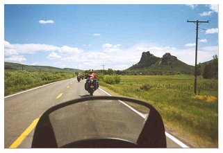
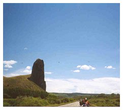
Highway 40 through Muddy Pass and Rabbit Ear Pass is especially
beautiful and curvy, and although it was hot, the scenery was
spectacular. We stopped and took some photos, knowing that they would
never reflect the magnificence of what we were seeing.
As we neared Steamboat Springs, the traffic thickened, and fully 50%
of the vehicles were Subarus. My friend David had told me that the car
to have in Denver is an Audi four-wheel-drive, if you can afford it. If
not, it's a Subaru. Of course, he said, the Audi owners don't actually
drive them in the snow.
We had thought of having lunch in Steamboat Springs, but after one
look at the carefully landscaped Super WalMart, and after idling in
traffic for far too long in the hot sun, we decided to let the tourists
have it and we turned around after gassing up. There was a circus
convention of some kind in town, and the parking lot of the gas station
we stopped at was full of young circus freaks and freak wannabes. We
took Route 131 south, through the tiny sub-towns of Yampa, Toponas and
Bond. This was the first real desert we had seen on our trip, and the
heat was intense. Route 131 is littered with the remains of mining
operations, slowly going back to nature. It is amazing how the
vegetation changes in such short a distance. We lunched outdoors near
Wolcott, where 131 crosses the interstate again.
We headed back east on I-70 for a few miles to Minturn and got off
on Highway 24 south (the Top of the Rockies Scenic Byway) toward
Leadville. The land instantly changed again back to evergreen and aspen
forest and the road was almost completely empty. I guess there was
nothing to buy at the end, so the tourons headed somewhere else. Just
before Leadville we rode through Tennessee Pass and I gave the high sign
to Kim, who was riding behind me for a change.
In Leadville we gassed up again under threatening skies, and the
nice man at the service station asked Gabby what she was riding, because
he thought she would make a great next ex-wife. When she told him she
was on a Triumph he was crestfallen. "I only date women who ride
Harleys." Leadville is an ex-mining town and looks it. We found though,
that the towns with the least to offer tourists were generally the most
genuine and more closely resembled the "real" Colorado.
 South of Leadville, we turned west on Route 82, in the San Isabel
National Forest, and headed to our first reserved campground. We had no
idea what these campgrounds were going to be like, because I had
reserved them on the web using http://www.reserveusa.com. We knew they
were U.S. Forestry Service areas, with pit toilets and no showers, so we
were apprehensive. We needn't have been, because that first night we
camped just above Twin Lakes reservoir in a beautiful spot. The pit
toilets were spotless, and the campground attendant was friendly and had
my name posted at the campsite. After a brief sprinkle, we had a camp
dinner and a beverage beside a crackling fire, and watched the stars
appear in a sky devoid of background light pollution. We toasted our
good fortune and crawled in our tents.
South of Leadville, we turned west on Route 82, in the San Isabel
National Forest, and headed to our first reserved campground. We had no
idea what these campgrounds were going to be like, because I had
reserved them on the web using http://www.reserveusa.com. We knew they
were U.S. Forestry Service areas, with pit toilets and no showers, so we
were apprehensive. We needn't have been, because that first night we
camped just above Twin Lakes reservoir in a beautiful spot. The pit
toilets were spotless, and the campground attendant was friendly and had
my name posted at the campsite. After a brief sprinkle, we had a camp
dinner and a beverage beside a crackling fire, and watched the stars
appear in a sky devoid of background light pollution. We toasted our
good fortune and crawled in our tents.
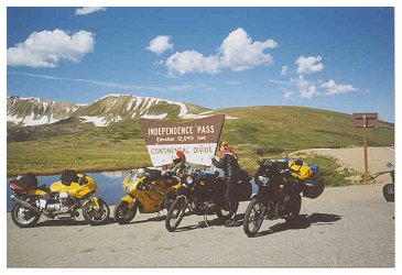
Wednesday, July 4: We headed out in the morning, and ate breakfast
at the Nordic Inn near Twin Lakes, a rustic German-themed restaurant and
inn that at times in its history been a stage coach stop and brothel. We
intended to cross Independence Pass and head to Aspen that day, but upon
reaching the summit, and discovering that there was a 4th of July parade
happening in Aspen, and with the Steamboat Springs traffic fresh in our
memories, we decided to go back down the way we came and skip Aspen
entirely.
 We took 285 to 291 to Salida, and had a great lunch at the 1st Street
Café. Salida is a nice town with little shops and some interesting
political art in the window of one establishment. It was hot, though. We
turned west on Highway 50 through Monarch, Monarch Pass, Sargents and
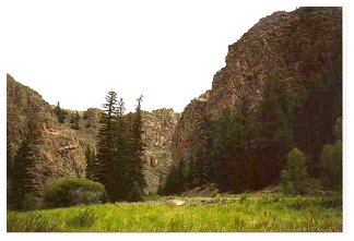
Doyleville to Highway 114, which took us back south. We traveled through
an amazing canyon near Cochetopa, and then through Buffalo Pass. There
was no traffic, and no anything. The terrain turned back to scrub desert
with mountains on both sides. The land flattened out toward Seguache,
where we got back on Highway 285 South. We stopped for gas in Seguache,
where the attendant told us he was a former CIA agent. I guess he lost
the need for secrecy and tight-lipped-ness since he left the agency.
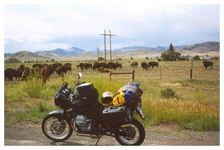
Highway 285 is flat and arrow-straight, but the scenery was beautiful.
We stopped to pet some friendly buffalo through the fence, and I somehow
lost my sunglasses.
We took 285 to 291 to Salida, and had a great lunch at the 1st Street
Café. Salida is a nice town with little shops and some interesting
political art in the window of one establishment. It was hot, though. We
turned west on Highway 50 through Monarch, Monarch Pass, Sargents and
Doyleville to Highway 114, which took us back south. We traveled through
an amazing canyon near Cochetopa, and then through Buffalo Pass. There
was no traffic, and no anything. The terrain turned back to scrub desert
with mountains on both sides. The land flattened out toward Seguache,
where we got back on Highway 285 South. We stopped for gas in Seguache,
where the attendant told us he was a former CIA agent. I guess he lost
the need for secrecy and tight-lipped-ness since he left the agency.
Highway 285 is flat and arrow-straight, but the scenery was beautiful.
We stopped to pet some friendly buffalo through the fence, and I somehow
lost my sunglasses.
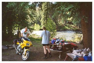
 We took Highway 112 to Del Norte and then 160 to South Fork, our
destination for the night. The campground at which I had arranged for us
to stay offered us a dusty tent space out by the busy highway (it turned
out it was more of an RV village than a real campground), so we left in
search of something better. We found Riverbend campground, and they
offered us tent sites right beside a tributary of the Rio Grande. It too
was an RV-oriented campground, but the tent sites were down a steep,
narrow gravel road, assuring our privacy from the diesel behemoths and
their whirring generators. The operators were very friendly, and some of
the other tent campers were incredulous at the Tennessee and
Pennsylvania tags on our motorcycles. We went off in search of food, and
got very poor service at a Swiss-themed restaurant with exorbitant
prices, and left before they ever got around to even getting us water.
We found another, less stuffy eatery, and had a decent meal. Crawling
the bikes back down the steep dirt road to our tents in the dark was an
adventure. We had a beautiful fire beside the river (free firewood
courtesy of the campground) and slept like babies.
We took Highway 112 to Del Norte and then 160 to South Fork, our
destination for the night. The campground at which I had arranged for us
to stay offered us a dusty tent space out by the busy highway (it turned
out it was more of an RV village than a real campground), so we left in
search of something better. We found Riverbend campground, and they
offered us tent sites right beside a tributary of the Rio Grande. It too
was an RV-oriented campground, but the tent sites were down a steep,
narrow gravel road, assuring our privacy from the diesel behemoths and
their whirring generators. The operators were very friendly, and some of
the other tent campers were incredulous at the Tennessee and
Pennsylvania tags on our motorcycles. We went off in search of food, and
got very poor service at a Swiss-themed restaurant with exorbitant
prices, and left before they ever got around to even getting us water.
We found another, less stuffy eatery, and had a decent meal. Crawling
the bikes back down the steep dirt road to our tents in the dark was an
adventure. We had a beautiful fire beside the river (free firewood
courtesy of the campground) and slept like babies.
 Thursday, July 5: We left South Fork on 149 North, and went through the
artist town of Creede, and then Lake City. We rode through Slumgillion
Pass, which was very fun, with very little traffic and passing lanes
everywhere. We stayed on 149 until we turned west on 50/92 to Sapinero,
which was to be our campground for the last night of the trip. The
campground was right beside the Blue Mesa reservoir, a huge man-made
lake devoid of vegetation. The campground looked like a gravel parking
lot, baking in the shadeless sun. We decided there was no way we'd be
camping there, and made plans to alter our route and arrive somewhere
else on our last night on the road.
Thursday, July 5: We left South Fork on 149 North, and went through the
artist town of Creede, and then Lake City. We rode through Slumgillion
Pass, which was very fun, with very little traffic and passing lanes
everywhere. We stayed on 149 until we turned west on 50/92 to Sapinero,
which was to be our campground for the last night of the trip. The
campground was right beside the Blue Mesa reservoir, a huge man-made
lake devoid of vegetation. The campground looked like a gravel parking
lot, baking in the shadeless sun. We decided there was no way we'd be
camping there, and made plans to alter our route and arrive somewhere
else on our last night on the road.
Highways 92 and 50 parted ways after Sapinero, and we took 92. Below
the dam was the beautiful Black Canyon of the Gunnison National
Monument, where we stopped to ponder the depths and take a break. We
headed through Maher and Crawford, and it was getting hotter by the
mile. We ate lunch in Crawford, and as we rolled out of town the bank
sign said 105 degrees. As we rolled toward Hotchkiss it got even hotter,
and the land was a baked desert. We got into Delta, CO, about 5:00pm and
quickly found our motel. After cooling showers and a few minutes of air
conditioning, we went walking around in search of food and thrills.
Delta is no tourist town, and most places in town were closed by 8:00pm.
We found a sports bar open and actually had a great meal. There is a
great auto lot in Delta filled entirely with American sleds from the 50s
through the 70s. Brad was particularly enamored of a huge Henney
commercial panel truck. We wandered down Main Street to Wanda's
Place, which thrilled Brad by having Guinness! We played darts and drank
beer, and ran off some locals by playing a Melissa Etheridge song on the
jukebox. A local cruised up with his squeeze on an original 70s custom
Norton, but he wasn't in the mood for chitchat or bike talk.
Friday, July 6: We got rolling early because we knew it was going to
be hot. We took highway 50 and turned south onto route 141. Immediately
after getting on 141, we found ourselves in a beautiful narrow shaded
canyon, and followed the river that created it for 20 miles or so. We
rolled through Gateway as the heat intensified. There was very little
traffic, and the red buttes along both sides of the road were
spectacular. About half way between Gateway and Nucla, we stopped at
Hanging Flume, an incredibly deep gorge with remnants of a mining flume
attached to the canyon wall 100 feet from the bottom. There were also
some very flat automobiles at the bottom, automobiles that were going to
stay there a long time.
 We were now on 145, and as we approached Telluride the traffic got much
worse, and we sat and sweated in traffic behind lines of SUVs. We
finally made it into town, which is in a beautiful spot, but packed with
tourists. We had a great lunch and an outdoor Italian bistro, where the
all-Italian female staff were slim and wore tight-fitting black blouses
and skirts. I bought the cheapest sunglasses in Telluride ($27.00) to
replace my lost pair. Everyone in Telluride looked incredibly
well-maintained. There was a spark of hope though: As we strolled down
the street, a crowd of mud-caked dirt bikes, smoking, noisy
non-street-legal two-strokes, pulled up the intersection in front of us,
and after the riders nervously looked both ways, blasted up the road. As
we got back on the bikes, a grumpy hippy chick was pruning the hanging
flower pots and dropping petals on the seat of my Quota.
We were now on 145, and as we approached Telluride the traffic got much
worse, and we sat and sweated in traffic behind lines of SUVs. We
finally made it into town, which is in a beautiful spot, but packed with
tourists. We had a great lunch and an outdoor Italian bistro, where the
all-Italian female staff were slim and wore tight-fitting black blouses
and skirts. I bought the cheapest sunglasses in Telluride ($27.00) to
replace my lost pair. Everyone in Telluride looked incredibly
well-maintained. There was a spark of hope though: As we strolled down
the street, a crowd of mud-caked dirt bikes, smoking, noisy
non-street-legal two-strokes, pulled up the intersection in front of us,
and after the riders nervously looked both ways, blasted up the road. As
we got back on the bikes, a grumpy hippy chick was pruning the hanging
flower pots and dropping petals on the seat of my Quota.
We turned South on 145 and headed through Rico (Suave?) which was
not so fresh and new and vibrant as Telluride. We were expecting big
things from a place called Stoner, CO, but there was just a small
RV/campground at Stoner Creek. No town, no sign, no "Stoner, dude"
T-shirts. Bummer. After Stoner the road followed the Delores River,
which looked to be some fine trout fishing water. We gassed up in
Delores and headed for Mancos State Park. The last few miles to the
campground were dirt, and we felt like Paris-Dakar contestants, eating
clouds of fine dust. The campground was fresh out of tent sites, but
would we be interested in a Yurt? Sure we would, rather than head out
that dusty road to try and find another place to stay. Our Yurt was a
fabric-covered round hut with electricity, running water, a ceiling fan,
and bunk beds. The campground folks said the yurts were usually rented
to hunters in the winter. It looked fine to us!
We cleaned up a bit and rode back down the dusty road to the town of
Mancos in search of food. Mancos is another non-tourist town, and
contained some interesting architecture just off Main Street. The main
drag through town turned to dirt a block or so off Main, but we found a
great inn/restaurant/bar called, appropriately, the Dusty Rose. We ate
outside on the porch, a delicious Italian meal, and sampled Fat Tire
Ale, brewed in Colorado. A local on a Ducati Monster was eating there as
well, and displayed to us during a short conversation that he knew very
little about his own bike, let alone any others. He was friendly enough,
though, and we enjoyed a great meal. We picked up a few more Fat Tire
Ales and took them back up the dusty road to our yurt. We built a small
fire in the fire pit provided and stayed up a while enjoying the night
sky.
Saturday, July 7: We got up early and ate one last cloud of dust
before hitting route 160 towards Durango. We arrived early and walked
around town looking for breakfast. There was a gaudy American motorcycle
themed bar/restaurant, but thankfully it wasn't open in the morning. We
wondered into the Durango Diner, truly local flavor if there ever was.
While we perused the menu, the cook told us the special was fresh
raspberry pancakes. I ordered one, and it was too big to finish. Gabby
ordered something called a Super Spud, and it looked like a small
football covered with cheese and green chili. Yum! The Mountain Bike
World Cup was happening in Durango, so fit people were everywhere. We
bought a few souvenirs for Becky, who was watching our cats, and saddled
up and headed towards Silverton on 550. Traffic, and the dreaded RVs
became heavy as we neared Ouray. There is a loop road near Ouray that
must be mecca to dirt bikes and ATVs, because they were everywhere. We
stopped for a drink and a break in Ouray, and encountered a strange
woman with a parrot, who seemed unnaturally protective of her bird.
 It was getting hotter as we rolled into Montrose. The bank sign said 99
degrees. We stopped at a drive-through car wash and rinsed some of the
Mancos dust off the bikes, and hit the Red Barn for lunch. We left
Montross on 50 and hit the first real rain of the trip as we again
neared Sapinero. Since we weren't staying in that furnace, we passed by
Sapinero and went to Gunnison, where we picked up route 135 to Almont,
and split off toward Taylor Lake Park. We found a beautiful camp spot at
Rosy Lane campground, a small self service spot along the Taylor River.
The campground actually gave us a price break for motorcycles (amazing)
and we paid $6.00. There was no water, but pit toilets and fire rings.
Rock climbers used this campground often, and climbed the rocks just
across the road. The area was picked clean of firewood, but I discovered
that the smaller dead standing aspens could be kicked over easily and
stomped into fire-sized pieces. Seeing our discovery, other campers,
like good little primates, crossed the road and began aping our
procedure. We enjoyed another beautiful evening and were lulled to sleep
by the moving water.
It was getting hotter as we rolled into Montrose. The bank sign said 99
degrees. We stopped at a drive-through car wash and rinsed some of the
Mancos dust off the bikes, and hit the Red Barn for lunch. We left
Montross on 50 and hit the first real rain of the trip as we again
neared Sapinero. Since we weren't staying in that furnace, we passed by
Sapinero and went to Gunnison, where we picked up route 135 to Almont,
and split off toward Taylor Lake Park. We found a beautiful camp spot at
Rosy Lane campground, a small self service spot along the Taylor River.
The campground actually gave us a price break for motorcycles (amazing)
and we paid $6.00. There was no water, but pit toilets and fire rings.
Rock climbers used this campground often, and climbed the rocks just
across the road. The area was picked clean of firewood, but I discovered
that the smaller dead standing aspens could be kicked over easily and
stomped into fire-sized pieces. Seeing our discovery, other campers,
like good little primates, crossed the road and began aping our
procedure. We enjoyed another beautiful evening and were lulled to sleep
by the moving water.
Sunday, July 8: Time to head back to Golden. We headed out on 50,
back through Doyleville, Sargents and Monarch Pass, and stopped again in
Salida at the 1st Street Café for lunch. Again it was excellent. Our
initial plan included heading west and south of Golden, through grant,
Bailey and Conifer, but we made the decision to head up through
Breckenridge and hook up with Interstate 70 at Frisco. As we rolled into
Breckenridge, it began to rain lightly. Breckenridge was awash in
development, and looked like Gatlinburg with better scenery and more
money. We didn't even stop, except when forced to by crawling traffic.
Finally exiting town, we sped through the strengthening rain to Frisco,
and got on the slab. Little did we know it, but we would be on this
short section of I-70 for the remainder of the day. The rain continued,
and traffic slowly came to a standstill. We all looked at each other and
grinned as we were pelted with rain, and drenched with runoff as the
cars in the opposing lane (which was moving) plowed through standing
water and splashed it all over us. Kim and I were ready to hit the
shoulder, and a group of Harley riders did just that, rumbling by at 20
or so miles per hour. But Gabby and Brad didn't want to risk it, so we
sat in the rain, occasionally starting the bikes and crawling forward.
We discovered later that Denver had been hit with a 50- or 100-year
rain, with severe flooding, and that's what was stopping traffic. We
eventually made it Golden at dusk, where our friends and hosts, David
and Erica, were wondering where we were. We loaded the bikes, showered,
ate a nice meal of buffalo burgers, and fell into bed, exhausted. The
next morning we said our sad goodbyes to David and Erica and to Gabby
and Brad and headed for Tennessee. Can we come back?
Back to
Trips |